Map Utility: Geotagging images using GPS log file
Tag: Map Utility, GPS, GP-E2, GPS Log, geotag, EOS Software, EOS Accessories
Tag: Map Utility, GPS, GP-E2, GPS Log, geotag, EOS Software, EOS Accessories


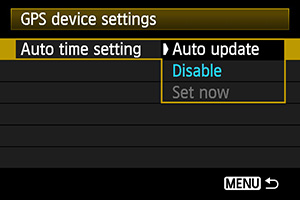
When you are travelling or shooting outdoor, you can create GPS log files of the route with the GPS logger function of GPS Receiver GP-E2. After shooting, you can use these GPS log files to geotag images taken with your second camera or friends’ cameras at the same time, which do not have location information, in the Map Utility.
Geotagging images using GPS Log file from GP-E2
In Map Utility, longitude and latitude will be added to an image in which the shooting time matches a time in the GPS log file from GP-E2 automatically.
Geotagging images manually
Even there is no GPS log file, you can still geotag an image manually by picking the shooting location from the map. (Only longitude and latitude will be added)
| Tips |