

The EOS 6D is Canon's first EOS SLR with fully integrated GPS capability. For users who like outdoor activities and travelling, it is a simple way to geotag images and videos* for future reviewing with a more vivid memory.
The antenna of EOS 6D’s GPS receiver is located under the top cover near the hot shoe, the GPS uses the common "L1" GPS band (1575.42 MHz). The accuracy rating of EOS 6D’s integrated GPS receiver is within 30m. To acquire GPS signals, bring the camera outdoors where the sky is unobstructed and aim it upwards.
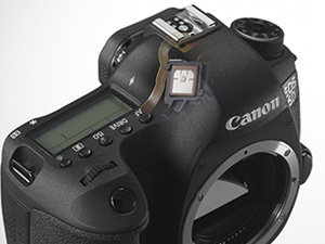 The antenna of EOS 6D’s GPS receiver is located under the top cover near the hot shoe. |
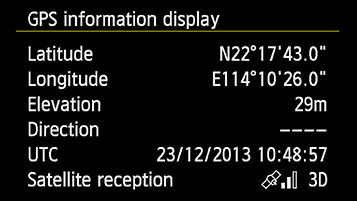
Once activated, the integrated GPS of EOS 6D takes around 30-60 seconds to acquire signals from GPS satellites. Once the <GPS> icon on the top LCD panel is constantly displayed, the following geotag information will be add to images and videos* taken automatically:
- Longitude and latitude
- Altitude
- UTC (Coordinated Universal Time)
- Satellite reception conditions
| Tips |
|
When <GPS> icon on camera’s top LCD panel blinks, signal is not yet acquired. When <GPS> icon is constantly displayed, signal has been acquired; images and videos* will be geotagged. |
|
When <3D> is displayed in Satellite reception, elevation can be recorded. However, elevation cannot be recorded when <2D> is displayed |
Battery Life
After enabling GPS function, the battery life of EOS 6D will be reduced a bit. For prolonged use of GPS function, backup batteries are recommended.
| EOS 6D with GPS Operation Battery life (GPS Logger is on) | |
| Position Update Timing | Number of shots, Approx. |
| GPS off | 1090 |
| Every second | 870 |
| Every 5 seconds | 1030 |
| Every 5 minutes | 1030 |
*During movie shooting, information at the start of shooting is recorded. Note that signal reception conditions are not recorded